Storm Barry brings flood fears in Louisiana
- Published
Thousands have been evacuated from at-risk areas
Storm Barry has made landfall in Louisiana, where officials have warned of potentially life-threatening floods.
The storm reached hurricane strength as it neared land, but has now weakened to a storm packing sustained wind speeds of 60mph (96km/h).
The system is crawling north-west at a speed of just 8mph, dumping heavy rainfall as it tracks inland.
The worst of the storm is expected to hit an area west of New Orleans, and affect the wider region.
Thousands have been evacuated from areas most at risk of flooding and other residents have been told to shelter in place.
More than 100,000 households in Louisiana are already without power, according to tracking tool poweroutage.us.
All flights in and out of Louis Armstrong New Orleans International Airport on Saturday were cancelled.
President Donald Trump declared a federal state of emergency in Louisiana before the storm hit.

What is the latest?
In its latest update at 16:00 local time (21:00 GMT), the US National Hurricane Centre (NHC) confirmed Storm Barry's winds had weakened.
But it said "life-threatening storm surge inundation" continued as it moved inland.
Before it made landfall near Intracoastal City, it was confirmed as the first hurricane of the 2019 Atlantic season.
As the storm's rain bands closed in, local journalists shared images of flooding in some residential areas.
Allow Twitter content?
This article contains content provided by Twitter. We ask for your permission before anything is loaded, as they may be using cookies and other technologies. You may want to read Twitter’s cookie policy, external and privacy policy, external before accepting. To view this content choose ‘accept and continue’.

At least one levee, in Plaquemines Parish in the state's tip, was already overtopped by water by midday on Saturday.
Officials have told residents there to immediately evacuate, if it is safe to do so, or risk being cut off for several days.
Louisiana's most populous city, New Orleans, looks set to avoid a direct hit from the hurricane - with the worst expected further west near the city of Lafayette instead.
Heavy rain is expected throughout the state.
Louisiana's governor, John Bel Edwards, has urged residents not to become complacent.
"I want to caution everybody. This is just the beginning," he said at a Saturday news conference.
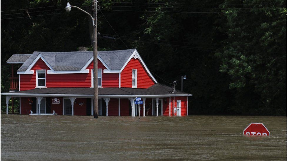
New Orleans has already been hit by flooding
With recent flash-flooding and heavy rainfall, there was particular concern about the flooding risk to low-lying New Orleans.
Most of the city's flood defences, improved after more than 1,800 died in Hurricane Katrina in 2005, are built between 20-25ft (6-7.6m) high.
The National Weather Service (NWS) earlier warned the Mississippi River could crest at 19ft or 20ft during the storm, but on Friday revised their estimate down to 17ft.
No city-wide mandatory evacuation is in place, but locals were told to hunker down and stock-up on essentials.

The city's emergency preparedness campaign has urged residents to remain vigilant and stay patient.
The NHC warned that "life-threatening, significant flash flooding and river flooding" would become increasingly likely across areas of south and south-east Louisiana as the storm moved further inland.
"The slow movement of Barry will result in a long duration heavy rainfall and flood threat from Sunday into next week", it said.

Is climate change to blame?

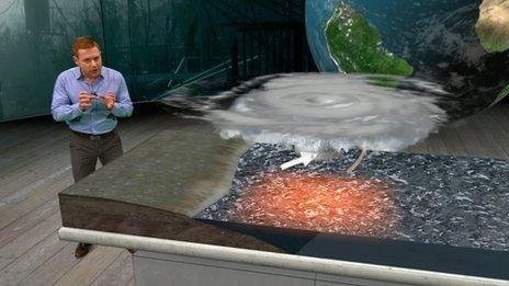
While there is no definitive link between climate change and Storm Barry, rising temperatures are increasingly a factor in making the impact of events like this more intense.
As the air has warmed over recent decades it is now able to hold much more moisture, meaning tropical storms are pre-loaded with large amounts of rain.
The warming world is also making these storms more sluggish. Over the past seven decades tropical events like Barry have slowed down, going 20-30% less quickly over land in North America.
This is what happened with Hurricane Harvey in 2017, when it weakened to a tropical storm and then stalled for days over the Houston area dumping enormous quantities of rainwater which cost lives and did huge damage.
Sea levels have also increased as a result of global heating, so if winds are blowing towards shore, this makes flooding much more likely during high tides.
- Published1 October 2016
- Published11 June 2019